Cyclones, monsters of the ocean
Names such as Andrew, Hugo, Allen, Mitch and Katrina symbolize one of the most devastating meteorological phenomena: the cyclone. When they are at their strongest, these giant tropical storms may be accompanied by winds of more than 250 km/h. Cyclones need only a few ingredients to form: a large mass of warm water (more than 27°C), an initial depression, and moderate winds blowing in a constant direction.
Cyclone, hurricane or typhoon ?
Cyclones are formed exclusively in the intertropical zone between 5° and 20° latitude on either side of the equator. They are called typhoons in the northwest Pacific Ocean, hurricanes in the North Atlantic and northeast Pacific oceans, and cyclones in the Indian and southwest Pacific oceans. Tropical storms and cyclones are identified by first names, alternating between male and female, in alphabetical order. These lists, prepared in advance by the World Meteorological Organization, are recycled every five years, except for the names of the most destructive storms, which are retired. Thus, Andrew, Gilbert, Hugo, Allen, Rita, Mitch and Katrina will never be used again.
How a cyclon forms
Among the hundred tropical storms which are formed above oceans, two thirds evolve in cyclones. When the Sun warms the top layer of the ocean, strong updrafts of warm, humid air are formed by convection, creating a low-pressure zone. This provokes the convergence of low-altitude winds, also loaded with humidity, which feed the rising movement. Once in contact with cooler air, the water vapor condenses and forms a storm cloud. The latent heat released by the condensation accelerates the rising of the air within a column that sucks up more mid-level warm, humid air. At the top of the cloud, diverging winds form and the air is expelled. As it descends, the air is heated and sucked in by the surface low-pressure zone. The cyclonic process has started.
The internal structure of a cyclone
A cyclone is composed of rain bands formed by convection of warm, humid air over the ocean. These convective cells are organized in spirals turning counter-clockwise (in the Northern Hemisphere), which are attracted to the eye of the cyclone, a zone of very low pressure (30 km in diameter). Because of centrifugal force, the winds do not penetrate to the eye but reach maximum speed (more than 250 km/h) in the eye wall, where they whirl in a circular motion as they rise. When they reach the top of the cloud, the air is pushed clockwise (in the Northern Hemisphere) toward the periphery of the cyclone, where it forms cirrus clouds. A cyclone can reach radius of 500 km and a depth between 10 and 15 km. Prevailing winds (such as the trade winds) propel cyclones at an average speed of 25 km/h.
Life and death of a cyclone
Using satellites, planes, radar, and probes, scientists have been studying cyclones for tens years in order to understand their evolution, from the formation of a tropical depression to the dissipation of the storm. Although the phenomenon is now well understood, it is still impossible to forecast the precise paths of cyclones several days in advance, as they can suddenly change direction or even double back on their path.
When a disturbance becomes organized around a low-pressure zone where winds are blowing at between 37 and 62 km/h, it is called a tropical depression. The depression develops into a tropical storm: the low pressure deepens, while winds rise to between 63 and 117 km/h. A tropical storm becomes a cyclone when wind speeds are above 118 km/h. In the eye that forms at the center of the cloud mass, the pressure drops to below 980 hPa. Deprived of its main source of energy, warm water, the cyclone weakens very quickly. The dissipation stage starts just a few hours after it travels inland. Pushed by the trade winds, cyclones move first from east to west, then tend to move away from the equator. When they reach subtropical regions, they encounter western prevailing winds that deflect their path toward the north or northeast (toward the south or southeast in the Southern Hemisphere. Some may reach latitudes of 40° to 45°.
Damage caused by cyclones
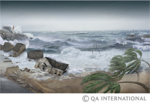
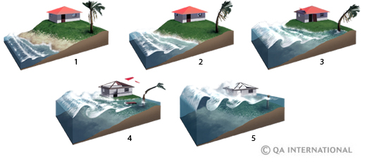
The mechanism that create cyclons plays an essential role in the energy balance of the planet, but it is also responsible for the death of an average of 20,000 people each year. Cyclones are accompanied by an unusual and devastating phenomenon: storm surges. Pushed by violent converging winds and sucked up by the storm depression, the ocean surface rises several meters under the eye of the cyclone. When the cyclone reaches the coast, this mass of water hits the shore and causes flooding, with tragic consequences: more than 300,000 people drowned during a cyclone in Bangladesh in 1970, when the sea rose 12 m. Violent winds rip up trees and destroy buildings. Due to torrential rains, rivers overflow their banks and landslides occur.

The Saffir-Simpson scale
The Saffir-Simpson scale defines five categories of cyclones based on atmospheric pressure, wind speed, and the height of the storm surge. The scale allows the amount of damage to be predicted.

| Category | 1 | 2 | 3 | 4 | 5 |
| Pressure | More than 980 hPa | 965-980 hPa | 945-964 hPa | 920-944 hPa | Less than 920 hPa |
| Wind speed | 118-152 km/h | 153-176 km/h | 177-208 km/h | 209-248 km/h | More than 248 |
| Tide height | 1,20-1,50 m | 1,80-2,40 m | 2,70-3,60 m | 3,90-5,40 m | More than 5,40 m |
| Damages | Trees and shrubs damaged; trailer homes, docks and mooring of small boats damaged. | Small trees uprooted ; mobile homes seriously damaged ; some roofs damaged. | Leaves ripped off trees; large trees uprooted; trailer homes destroyed; some roofs, windows and doors of houses damaged. | Traffic signs thrown to the ground; roofs, Windows. and doors of houses seriously damaged. | Some buildings destroyed; many roofs of houses damaged. |


